Volcán Tajumulco Tour: How to Hike Central America’s Highest Peak?
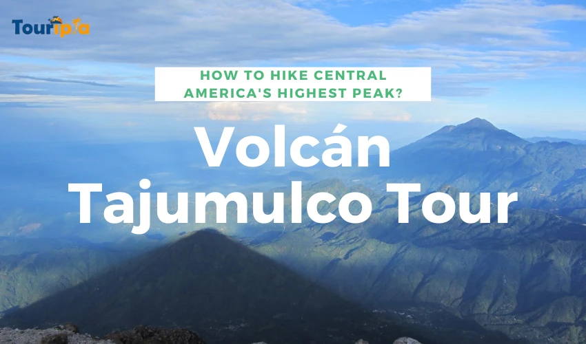
The Volcán tajumulco tour will surprise you in both challenging and amazing ways with panoramic sunrise views. Volcán tajumulco is the highest peak of central America with 13,845 feet height. Not only this, in fact this peak hold both cultural and historical significance.
Guatemala is a famous country in Central America that is famous for hiking, eco-tourism and natural scenery.
In this blog post, we will guide you how to hike on this peak along with in-depth details of Volcáno Tajumulco. Don’t skip reading!
What is Volcán Tajumulco Tour?

Before understanding what actually this tour is, you should know the history behind this. Want to witness one of the most beautiful sunrises within Central America? Tajumulco Volcano should be your finest destination.
As an adventure seeker, there’s a lot to do on this peak. Not only this peak provides adventure seekers an amazing hiking opportunity but more than this.
Tajumulco is located in the western Guatemala of San Marcos department and often considered as “highest peak” within Central America’s region. If we talk about Guatemala, this place is often considered as the heart of Mayan world where you will find various archaeological sites.
How it Formed?
This western Guatemala’s is formed over time from different layers of hardened lava, pumice, and volcanic ash. Moreover, it is a large volcano with a conical shape, commonly referred to as stratovolcano. The volcano was built on the top of an escarpment that faces southwest.
The volcano is made of andesitic-dacitic lavas. In this Volcan Tajumulco guide, you may be thinking how it looks like? It looks like two summits with one summit having a crater that is 50-70 meters wide. Other than two summit, it looks like lava flow from the north side summit.
Significant Role in Guatemala’s Geology and Ecosystem
Tajumulco plays an important role in Guatemala’s Geology and Ecosystem as it is considered as the highest peak of Central America, serving the landscape and famous stratovolcano. If we talk in terms of ecosystem, this landscape or peak’s elevation levels support various ecosystems.
At the summit, from lush lower slopes to alpine conditions, this place is a unique habitat for animal & plant life. Biosphere Reserve is the famous area of Tajumulco, protected area highlighting its ecological importance. Tajumulco features an elevation of 4,203 meters (13,789 feet).
Best Time to Hike Volcán Tajumulco

The temperature of Tajumulco ranges between 49° / 21°F and 46° / 26°F, from February to May. Due to its high altitude, the temperature of peak is different from the temperature of other parts of the region. During the wet season, you can expect minimal rainfall and snowy conditions.
For favorable hiking conditions, dry season is one of the best times, from November to April. Even during the dry season, you may experience that clouds can impact overall visibility.
At night time, the temperatures drop significantly especially at the summit. Also, winds can be strong and variable.
Weather-Related Tips: What to Expect at Different Altitudes?
The weather at volcano changes within no time so be sure prepare yourself for changing weather conditions. Tajumulco hike Guatemala requires proper planning and effort from tourists. Here’s a breakdown of helpful tips for base camp, mid-section and summit.
Tips for Base Camp
Base camp of this volcano is approximately 3,600 meters / 11,800 feet where you will experience relatively mild weather conditions.
Here are some useful tips for basecamp:
- Wear clothing in layers to accommodate the needs of different weather conditions.
- For colder temperatures, bring a small sleeping bag to combat coldness issues.
- Prepared for wind even if the weather is good and do not forget to bring windproof jacket.
Tips for Mid-Section
The mid-section of summit is approximately 3,800 – 4,000 meters / 12,470 – 13,123 feet. As you move your step upward, you will feel like temperature gradually changes. So for mid-section, you should follow these tips:
- Make sure that you have wind-proof jacket and gloves with yourself to deal with coldness issues.
- Keep your essential gear in a waterproof bag to save from rain or water.
- Use a hat to keep your head warm and do not forget to use scarf or neck gaiter to protect your face from wind chill.
Tips for Summit
The summit is approximately 4,220 meters / 13,845 feet where weather will be extreme so be prepare for this by following some useful tips.
- Bring extra layers with yourself along with down jacket or insulated coat.
- To keep yourself warm, wear hat, gloves and warm clothes.
- Make sure that your face is covered to get maximum protection from wind or sun.
- At higher peaks, the wind can be sudden and dangerous. Make sure to adjust yourself accordingly.
- The dry air comes with dehydration issues so drink plenty of water to get hydrated yourself.
- Apply sunscreen to avoid yourself from sunburn type issues.
Importance of checking weather forecasts before your trek save yourself from potential challenges. Do not forget to follow these tips for different types of elevation gain.
Preparing for the Tajumulco Trek
For Santa Maria volcano hike, you need to prepare yourself both mentally and physically. Apart from checking weather conditions and temperatures, be sure to get prepared in other different ways. Let’s take a look at how can you make preparation for hike trek.
Physical Fitness Requirements
The hiking to Volcán Tajumulco is often considered as moderate to difficult level with different types of physical fitness requirements. The hike’s route difficulty mainly comes from terrain level, altitude and altitude sickness.
Here are some physical fitness requirements that are needed:
- Build your stamina with cardio exercise like by running, cycling and swimming.
- Must do strength training like strengthening your legs, back muscles and core with multiple exercises like squats, planks and lunges.
- Practice hikes by increasing the difficulty level and duration of your hikes to minimize the conditions of this hiking trail.
Difficulty Level
The altitude of Tajumulco makes the hiking challenging because there is less oxygen at high altitudes. Also, the terrain of Tajumulco is challenging especially at higher altitudes. If you don’t prepare yourself beforehand, there are chances that you may face altitude sickness issues.
No doubt the hike difficulty level ranges between moderate to challenging but the views are rewarding and hike can be done overnight. We assure that you will not forget this hike experience ever in your life.
What to Pack?
For hiking, you need to pack travel essentials and dress appropriately so you could not face any major issues. The following are some things that you should pack with yourself:
- In clothing, you should pack in layering according to various temperature variations.
- For footwear, do not forget to bring sturdy shoes that will help you in hiking.
- Must have essential camping gear like tent, sleeping bags, cooking equipment, and water purification.
Permits and Regulations
Maybe you are wondering “does one need a permit to hike or not?” A permit is must to hike on Tajumulco, no matter what your fitness level or how much you expert in hiking. The cost of the permit is relatively inexpensive which ranges between $2 to $5 for one person.
The following are some documentations that you need for hike:
- Passport
- National ID card
- Travel insurance
- Guide requirement
- Follow group size and regulations
Finding a Guide
Hiring a local guide is essential and recommended for multiple of reasons especially for Volcan Santiaguito hike. If you are experienced hiker, it may be easy for you pass the trail but for beginners and mid-level experts, it will be good to hire a local guide.
In nearby cities, many tour operators provide services to hikers for their convenience, safety and comfort. They will not only guide you about hiking route but also help you with essential gear, transportation, guides, and permits.
Here are some benefits of hiring a local guide:
- Local Expertise
- Safety
- Logistics
Safety Tips for High-Altitude Treks
No doubt hiking to Volcan is rewarding and exciting adventure but still you need to follow tips to keep yourself safe. Hiking at high altitudes comes with unique challenges and potential health risks. Below are key safety tips to ensure you stay safe during your trek.
- Stay Hydrated
- Pack the Right Gear
- Know Your Limits
- Be Prepared for Changing Weather
- Stay On the Marked Trails
- Avoid Overexertion
Signs of Altitude Sickness to Consider:
- Headaches
- Nausea
- Dizziness
- Shortness of breath
- Loss of appetite
How to Prevent Altitude Sickness Issues?
Altitude sickness issues normally occurs when you go for elevation gain of more than 2,500 feet and your body doesn’t have enough power to balance oxygen levels. As you go higher, the oxygen in the air becomes more difficult to breathe, which can cause various symptoms.
Here are some effective ways to prevent altitude sickness issues:
- Proper nutrition
- Avoid smoking and alcohol
- Use doctor prescribed medicine
- Avoid Overexertion
- Climb Slowly
- Take some rest during hiking
Tajumulco Tour Routes
Here are some popular routes for getting towards to Tajumulco.
1. San Marcos Route
Starting Point
- San Marcos La Laguna (Lake Atitlán) or from the town of San Marcos.
Difficulty
- Moderate to difficult
Duration
- 2-3 days
This route is known as the most common route for going to Tajumulco Volcano and contains normally 2 days. Your first day will be spend by hiking up to a base camp where you will be camping in night. On the very second day, you make final ascent to summit where you will be rewarded with amazing views.
2. Tacaná Route
Starting Point
- The village of La Cumbre or from the Tacaná volcano area.
Difficulty
- Moderate to difficult
Duration
- 2-3 days
As compared to above-mentioned route, this route is less traveled and alternative route but still provide visitors an amazing view. This trail will let you through the northern side and often less-crowded. On this route, you will start trekking through forests and terrain.
3. Los Encuentros Route
Starting Point
- The town of Los Encuentros.
Difficulty
- Moderate
Duration
- 1-2 days
This route starts from the western side of Tajumulco Volcano. Los Encuentros route is ideal for hikers who are short on time but still want to enjoy rewarding experience. Route is far shorter and less strenuous as compared to above-mentioned routes.
2-Day Itinerary of Tour of Volcán Tajumulco

Day 1
For volcano lovers, hike to Tajumulco is a must-do activity. Here is a detailed breakdown of day 1 itinerary activity with timings.
5 am: Start your adventure journey by leaving your hotel room.
5:15 am: Drive approximately 2 hours to San Marcos.
7:30 am: When arrive at San Marcos, fill your hunger with delicious breakfast at local restaurant.
8:30 am: When you freed from breakfast, move towards to Tuichan where you will find pathway.
10:00 am: Your hiking journey starts.
2:30 pm: Arrive at main basecamp of the summit.
3:00 pm: For some relaxation, do camping and eat lunch.
6:00 pm: From the second summit of Volcano, amaze yourself with beautiful sunset at 4100 meters above sea level.
7:00 pm: Finish your first day hiking journey by eating delicious dinner and drinking hot drinks.
Day 2
The main thing of Xela to lake Atitlan tour is to see beautiful sunrise views and capture those views. This is an impressive sunrise that will make it worth to climb. Let’s take a look at how you should start your second day.
4:00 am: Wake up early so you can’t miss beautiful sunrise views.
4:30 am: Start hiking before it’s too late to hike.
6:00 am: Reach to the summit and enjoy the sunrise views.
8:30 am: Return back to basecamp, relax and eat some breakfast.
10:30 am: Now start hike down.
1:00 pm: Eat lunch at local restaurant with beautiful views.
2:00 pm: Pick transportation and arrive at Xela within next 3 hours.
What to Expect During the Volcán Tajumulco Trek?
Hike to Tajumulco peak is a memorable experience that combines various experiences into one form. Here what you can expect during Tajumulco Volcano climb:
1) Scenery
While hiking towards summit, you will see beautiful scenery in the form of lush pine forests, valleys with wildflowers, and dense cloud forests. Once you reach the summit, you will enjoy panoramic views of landscapes and volcanoes including:
- Volcán de San Pedro
- Volcán Atitlán
- Volcán Acatenango
If you are on early morning or night hike, you need to expect beautiful views of sunrise or sunset. From the summit, this place is best known for beautiful views of sunrise.
2) Challenge
Most of the tourists especially adventurous ones want to challenge themselves with hiking or climbing. Challenging hikes in Guatemala like Tajumulco with highest elevation gains, altitudes and steep/ rocky terrains. There are chances that you may face mild altitude sickness issues.
Other than mild altitude sickness, you can experience steep or rocky terrains and higher elevation gains. On the first day, you can face these challenges but there’s no need to worry about with such challenges.
3) Great Trekking Experience
Tajumulco Volcano hiking tours comes with one of the great trekking experiences that no one will ever forget.Stunning views from Tajumulco features base camp, camping, summit day and summit views experiences.
Not only this trek is about hiking but also camping, beautiful views, local experiences and delicious cuisines on the way. If you are with your tourist guide or operator, you can enjoy a lot than you might think as book a Tajumulco Volcano tour is convenient for many reasons.
4) Wildlife & Nature
Along the trail, you will find different types of plant life like dense forests, alpine vegetation and birds such as hawks and hummingbirds. At higher elevations, it is hard to find larger animals. Apart from wildlife, you will find nature.
The weather can change anytime so be prepared for this. At lower elevations, you may face warmer weather conditions but at higher elevations, the weather is cloudy and cold. Near the top, there are chances that you can face windy or foggy weather conditions.
5) Cultural Experience
The last but not least is that Summit Tajumulco offer cultural experiences too. Most of the Tajumulco Volcano tour operators comes you through the local villages, before or after hike. Normally, these types of villages are home to Mam people where you will see their way of life.
Most of the tourists want to experience this hike with tour operators as they guide tourists with amazing cultural life experiences. You guide operator will not only guide you about the trail but also share information about the volcano, the environment, and the local culture.
Challenges of the Trek & How to Overcome?
Elevation changes and maximum elevation of Tajumulco Volcano comes with some potential challenges. Following are some challenges with mitigation:
1. Altitude Sickness
The first most common challenges that most of the hiker’s face is altitude sickness. At the peak, the air contains less oxygen which can cause altitude sickness. Some of the symptoms of altitude sickness are:
- Headaches
- Nausea
- Dizziness
- Shortness of breath
How to Mitigate: If you want to reduce this challenge, it’s important to acclimatize before the trek.
2. Steep & Rugged Terrain
When you hike to the summit, you may face steep, rugged and uneven terrain. The trail becomes quite challenging especially when you are near to the summit. On this terrain, you need to maintain footwork grip.
How to Mitigate: Wear sturdy, high-quality hiking boots and adjust support through hiking poles.
3. Variable Weather Conditions
On highest volcano in Central America, you can experience variable weather conditions. Sometimes, you may face warmer weather conditions while on some other time, you may face uneven weather conditions.
How to Mitigate: Pack in layers with both warm and loose clothes to adjust accordingly.
4. Camping and Sleeping Conditions
If you want to camp at the base camp, you will need to be prepared for basic conditions. Tents are typically provided by your guide, but the sleeping area can be uncomfortable. It’s common for the air to be cold, and sleeping on the ground can be rough.
How to Mitigate: Must pack high-quality sleeping bag and bring thermal layers for enough warmth.
Summing Up!
The volcán tajumulco tour hiking experience will be incomplete without reading this helpful guide from start to end. Whether you are adventurous, promote eco-tourism, hiker or history enthusiast, this amazing hiking trail in Central America surprise visitors with beautiful views, challenging hike and unforgettable fun.
For adventure tourism and natural beauty in Guatemala, most of the tourists’ flock to this area for ultimate enjoyment.
Start planning your Tajumulco trip today by booking your reservations in advance and it is recommended to go for reputable tour guide operators.
Frequently Asked Questions
1) Is Tajumulco worth it?
Yes, Tajumulco is worth doing hike for all type of hikers both beginners and experienced ones with scenic views.
2) Can you climb volcan tajumulco?
No doubt volcan tajumulco is the highest peak of Central America but you can climb with moderate to difficult hike conditions.
3) Is volcán Tajumulco active?
The volcán Tajumulco is active as it is located atop the remains of an older volcano and has two peaks.
4) When was the last time Tajumulco erupted?
Tajumulco was erupted back in 24 October 1765 with both cultural and historical significance.
5) Is Tajumulco safe?
Overall, the Tajumulco is safe but it is recommended to take increased caution by following safety precautions.
6) How much does it cost to go to the volcano in Guatemala?
It all depends on your travel itinerary and other details. Normally, it is not too much expensive.
7) What city is near the Tajumulco volcano the highest in Central America?
San Marcos is the city that is located near the Tajumulco volcano the highest in Central America.